Android Apps
[work in progress]
I have an old Android Nexus tablet that was collecting dust. Thought I’d see what was available that might serve as a backup to my iPad/Stratus setup (the Nexus has a built-in GPS and more screen real estate than my iPhone, and it was sitting in a drawer unused, so why not?).
This isn’t a comprehensive review of the platforms. I’m not going to use an Android app to plan a flight, file a flight plan, get a DUATS briefing, check weather, etc. I’m very comfortable with ForeFlight for that, and don’t have a reason to change.
My focus is on the apps generally, how usable they are if, say, I was being vectored for an approach and my iPad and G430 failed suddenly. (By the hand of a DPE, say.) If I was going to grab the Nexus from my flight bag and fire it up, how useful would it be to (re)acquire situational awareness, find and brief the appropriate approach plate, etc.
Just for the sake of completeness, I also downloaded Garmin Pilot, which has a 30 day free trial.
Details:
- Nexus 7 (2012), 8GB storage, factory reset and used only to compare these aviation apps.
- Android 5.1.1
- Avare 7.4.4
- FltPlan Go 2.9.0
- Garmin Pilot 5.4.3
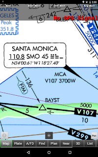
Avare’s charts are poor quality. They look like scans of paper documents (?), rather than rendered vector images. Compare, these Avare screenshots:
 |
 |
 |
 |
 |
 |
FltPlan Go definitely has the more polished user interface, too. (One caveat: I didn't initially see the "download" button, nor intuit that the icon bar on the left could be scrolled. I like the ForeFlight "More..." approach.)
With everything “packed” (local TAC, sectionals, IFR low charts, A/FD pages, approach plates, airport diagrams, etc.), FltPlan Go gobbled up 2GB of data transfer - there were a couple of ‘failed’ downloads (a 573MB sectional chart) that each time restarted from 0. My back-of-napkin calculations, going by FltPlan Go’s reported download sizes, is 1.2GB in storage used with downloading Victor Law SW, IFR Terminal, L.A. and San Diego TAC, SW Sectionals, CA procedures, A/FD Pacific, and Airport Diagrams.
Asare's downloads used about 338MB of data, storing 325 MB in total, 316 MB of that 'data' (9.6 MB for the app itself).
Avare has a handy “find” function I could use, to, for instance, locate an intersection (“DANAH”) and navigate directly to it:
[todo]
Putting a flight plan into Avare, conversely, is less intuitive than what I’m used to:
[todo]
Putting a flight plan into FltPlan Go works a lot more like ForeFlight, and was very straightforward. Notice it interpreted a victor airway (V23) properly and auto-populated all of the en route intersections:
[todo]
Meh. I'm gonna just stick screenshots here and organize them later. Long and short: Avare is too rough around the edges and foreign. FltPlan Go looks pretty damned good. Garmin Pilot is awesome, might even tempt me to switch from ForeFlight at some point, but the free trial doesn't include geo-referenced approach plates and the pricing ($74.99 + $74.99 for IFR) gets it up into ForeFlight territory, so, that experiment ended quickly. (658MB storage used, 673MB data usage, for roughly the equivalent setup as Avare and FltPlan Go, FWIW.)
(Some definite funkiness going on with Avare's charts...)


Comments
Post a Comment